

Bee forage map
/“Will you put it inside the hive and ask the bees to attend a daily briefing?” was my sister’s amused response when I mentioned I was working on a bee forage map. Actually, the idea is that I learn from the bees. They’re very efficient at what they do. I’d like to lend them a hand if I can, and a bee forage map is one tool to assist me to do that.
The idea of a bee forage map is to see what’s within the range of a particular hive or site. I’d read about them online, but when Tim Malfroy discussed them at the natural beekeeping course, I added it to my ‘to do real soon’ list. Honey bees will most commonly fly one to two kilometres from their hive to forage, but can range as far as five kilometres, depending on the quality and quantity of forage on offer.
To kick off my map, I visited http://bees.morkland.org/coverage/. This site offers a handy tool that draws five concentric circles, to indicate one to five kilometres, from any location you nominate.
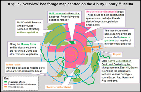
Let’s say you plan to keep bees on the roof of the Albury library museum. Below is how the map would look. It’s overlayed on a google map, so on the site you can zoom, view the satellite image and move around within it.

Source: Google map generated by http://bees.morkland.org/coverage/
From here, and still working at about that 5km radius scale, I roughly marked on my map where I thought the potential forage areas may be. Remnant and planted native vegetation, parks, reserves and gardens (this is an urban area) are all in the mix. As Rob Fenton reminded me, things that might be barriers or threats to the bees can also be added. My reading hasn’t yet got into detail about how bees respond to freeways or airports, but has included some of the problems that some practices may have (like spraying of orchards and locust control). I noted these on my map as well.
Here’s what our practice site’s map might look like with these details added (click on the map for a larger view).
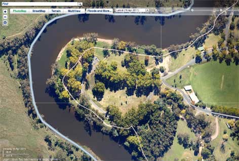
From there I decided to ‘zoom in’ to create a more detailed picture of the 1km zone surrounding my hive. First, I used a satellite map. The google one is good, but for Albury the nearmap.com ones are even more detailed. I like that you can view different satellite images over time and the resolution means you can use it to label individual trees (should you so desire!).
For example, Noreuil Park, Albury, looks like this on nearmap (click the picture to go to larger version on their site):
I’m using the satellite map to help me identify plants in the area. Of course that can’t all be done while sitting at a computer screen, so I’ve been out in the neighbourhood to ground check what’s there. For now I’m focussing on species at our place and public land, but clearly in an urban area other people’s backyards may contain some valuable forage species too.
I’m having a great time collecting this information. It helps me pay attention to what’s there and it’s a great excuse to work on my plant identification skills, not to mention just spend some time in the neighbourhood. I take the camera with me, and when I’m unsure of a plant I take pictures of the leaves, bark, buds, flowers and whole plant, to help me research it when I return. (Or ask my plant-smart friends!).
Admittedly, identifying and mapping every plant within one kilometre is a pretty big job (let alone my plans to map to 5km). It will be an ongoing project. And, to make it more manageable, I’m focussing initially on plants the bees are actually visiting. Yep, the bees are showing me what to take notice of. After all, it’s the species they visit I am trying to track. Besides, plant identification without a flower is usually harder than with it! As the bees’ focus changes through the seasons, so will mine!
Read on for more about bee forage.
